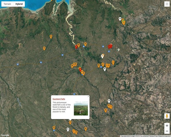
Driving into Kakadu on July 19, we passed a field of about 60 wallabies and stopped for pictures. This
was the only shot of one in action.
We also got our first view of the deliberately set fires during the cooler dry season.
This was aboriginal practice and it has been resumed around the national park. The aborigines found this
practice to be helpful for some of the wildlife they hunted and also reduced the risk of more destructive
fires during the hotter September-November dry period. We saw numerous small fires in smoldering brush
over the next 3 days.
On July 20 we started before dawn with the yellow water billabong cruise, which is near our lodging in
Cooinda, lowest red dot on the map.
Sunrise with ground fog from overnight cooling:
The sunrise and sunset cruises are the best time for light and the abundant bird life. Billabongs are the
lakes and ponds that remain in dry season when the summer floodwaters recede.
We soon saw the Australian jabiru, for whom the main town in Kakadu is named.
The comb-crested jacana walks on the lily pads.
Brolgas, sometimes known as Australian cranes:
Crocodiles were abundant in the billabong.
White bellied sea eagles:
Sacred kingfisher:
Nankeen night heron, known to local Aussies as the Paris Hilton bird because it seems to enjoy posing for
photos.
We never saw this entire blue heron at one time. This was the head shot.
The Australasian darter was drying its wings.
Billabong view after the fog burned off:
Only one of the crocs we saw was not in the water.
We next stopped at Nourlangie between Cooinda and Jabiru. We saw this sulphur-crested cockatoo on the way
to the aboriginal art site.
Hunting kangaroo with spear thrower:
The stick figures are Mimi Spirits.
We found this spirit description amusing.
The rock art is nearly always on rocks with overhangs to shade from the sun.
Past the rock art caves the Nourlangie trail climbs up enough for a view above the forest.
We next drove past Jabiru to the park boundary at the East Alligator River. Cahill’s Crossing to Arnhem
Land is partially under water at high tide, so crocodiles lie in wait where water flows over the road at
right and one is crossing the road here.
We took the 2.5km Bardedjilidji walk through rock outcroppings just south of Cahill’s Crossing.
We finished our day at Ubirr (farthest NE orange pin), which has the most extensive rock art in
Kakadu.
Ubirr is usually not accessible during summer flood season.
Liz at one of the rock art displays:
Detail fish paintings:
Sometimes later paintings were done on top of earlier ones.
We know that this Thylocene painting is at least 4,000 years old because the animal became extinct in
this region then.
This art is on a ceiling far off the ground and it is not known how it was done.
Current aborigines believe it was done by Mimi Spirits.
We climbed to the Nadab Lookout with a panoramic view of the floodplain.
View NE toward Arnhem Land:
Rainbow Serpent rock art:
These places we visited June 20 are those you read most about in guides to Kakadu. By hitting all of them
on day one, we had time to get more off the beaten track the next two days. Liz decided right away that
she wanted a full day trip into the Arnhem Land aboriginal reserve. The other day turned out to be Gunlom
Falls, decided on very short notice.
Many thanks again to Joe Cali, who gave us tips about both Red Center and Top End Australia and
encouraged us to drive a rental car into Kakadu with flexible plans. He did this himself with an ailing
friend in January 2018, height of the monsoon season. In that situation they did flightseeing for
locations not then accessible, and of course the escarpment waterfalls were much bigger than they are in
dry season.
