Our first view of Uluru was from theplane arriving at Yulara from Sydney on July 14.
We drove to Kings Canyon and returned to Yulara on the afternoon of July 15. We drove out to the sunset
viewing area after first checking out the climbing base at the Mala carpark.
Here's a closeup view of the western edge of Uluru about half an hour before sunset.
The arkose sandstone is hard and relatively smooth on the outside and resists erosion. The solid rock is
like an iceberg, supposedly 6km deep underground. If there is weak point on the surface, deeper pits and
caves can grow.
We stopped on the road NW of Uluru and fired away with the camera as the color changed. We had the
maximum red color about 5 minutes before sunset.
Scattered clouds dimmed the view a few minutes later.
Just after sunset those clouds lit up.
We returned to the sunrise viewing area early the next morning.
The optimal light illuminated Kata Tjuda at left distance better than Uluru.
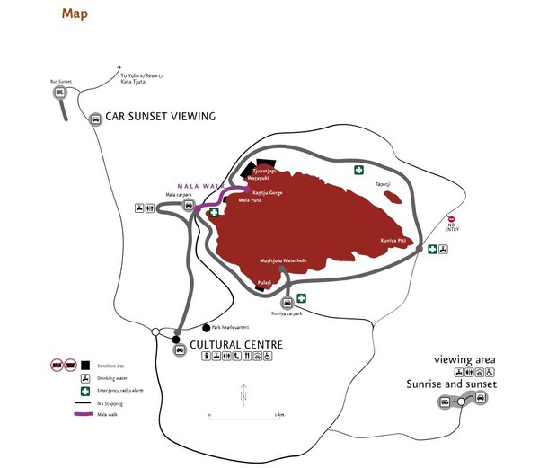
From the map above you can see that the sunset viewing area is NW of Uluru, better in winter, while the
sunrise viewing area is SE of Uluru, better in summer. This makes some sense in terms of temperature
comfort.
We left and drove counterclockwise around Uluru before starting our climb. Here is the eastern extremity
about 8AM.
Here is the northeast side with a lot of pitting.
This is probably the right place to view sunrise in winter.
After the climb we took the Mala Walk on the NW side. Soon we reach the first ground level cave.
The vertical black streak is a water channel when it rains.
Some aboriginal art, estimated between 100 and 1,000 years old.
The vertical blue/gray lines mark where the arkose sandstone is still actively eroding.
The erosion can work its way upward.
As at the far eastern end, there are sometimes fallen boulders.
Soon we approach Kantju Gorge, with watermarks visible high above.
Closer in, there is the illusion of a waterfall.
But at the peak of dry season there's only a little water in that depression beyond the right side of
the railing.
We next spent an hour in the Cultural Museum. Liz came close to buying a carved Perentie, Australia's
longest monitor lizard.
We then drove to the Kuniya trail.
The sign describes how certain Uluru rock features are interpreted by the aborigines.
Crooked horizontal ridge here is feature #1.
Series of 3 caves is feature #2.
The black water channels funnel to the permanent Mutitjulu waterhole.
Cracks are features #3&4 and diagonal ridge is #5.
Mutitjulu waterhole:
Sun glare made pictures of rock channels above impossible.
Some rock art:
On July 15 we signed up for the outdoors Sounds of Silence Dinner, starting with champagne toast at
sunset.
There was a campfire with didgeridoo player.
After dinner an astronomer gave a quick view of the southern sky. Then we walked through Bruce
Munro's Field of Light Art installation.
The 58,000 lights gradually change colors.
