Kings Canyon, Australia, July 15, 2019

Postby Tony Crocker » Tue Aug 06, 2019 11:28 pm

We arrived in Yulara, Australia about 1:30PM on July 14 and drove 300km to Watarrka National Park. The Red Center sector of Australia looks quite different from other deserts I have visited.
IMG_3175.JPG

These trees, Kurkara or Desert Oak, were abundant. The skinny ones are juveniles, which drip any rain near their base until they sink a deep taproot. Then they spread out to a more typical tree appearance. The Alice Springs/Yulara region averages about 11 inches rain per year, most of it in summer due to latitude 24-25 degrees. The closest North American analogy is the Sonoran desert of northern Mexico and far southern Arizona. Elevation is about 1,500 feet. The mountains in this region top out at 5,000 but evidently that's enough to double rainfall vs. flatter, more barren deserts to the west and southeast.

There's just one hotel out there and we arrived not long before sunset upon the western end of the George Gill Range.
IMG_3196.JPG


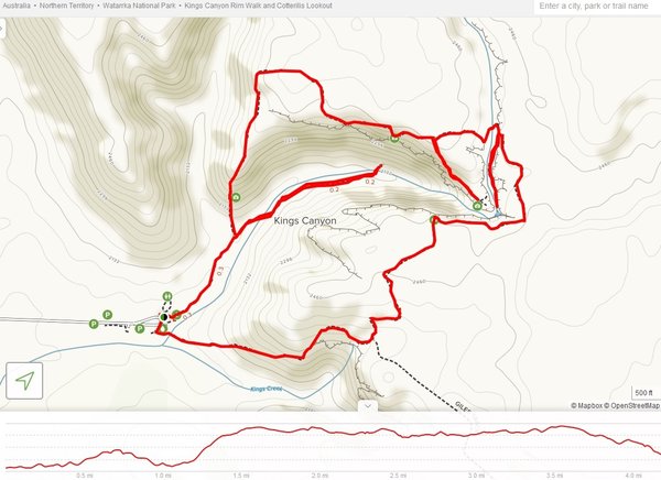
The next morning we drove out to Kings Canyon to hike the 6 km loop trail starting at 7:45AM. We planned to be here in July, the coldest and driest month. Early morning temps were about 45F with highs about 65F. There were steady moderate winds on top so I wore my old ski jacket all day.
KingsCanyonTralMap.jpg

We also hiked the spur trails on the NE side of the map to Cotterill's Lookout and into the Garden of Eden.

The steepest ascent is at the beginning, though it's only about 500 vertical feet.
IMG_3212a.JPG

IMG_3217.JPG


Once we're up a bit, the sun starts to illuminate the southern wall of the Canyon.
IMG_3222.JPG


We are still shaded this early as we walk east on the north rim. Liz climbed a distinctive rock here.
IMG_3229.JPG

Her backlit hair is the closest we came to seeing a corona on this trip. :twisted:

Over the next 15 minutes we move gradually into the sun.
IMG_3239.JPG

IMG_3253.JPG


The trail goes through a narrow crevice where I couldn't resist the photo opportunity.
IMG_8106a.JPG


Soon we reach a view from the north rim west toward the trailhead.
IMG_3255.JPG


Cotterill's bridge was built over a crevasse.
IMG_8117.JPG

IMG_3281.JPG

IMG_3284a.JPG


This gets us to the highest viewpoints.
IMG_8111.JPG

IMG_3296.JPG


I took this picture from the north rim sitting down because a stiff breeze was blowing toward the cliff on my left.
IMG_3291a.JPG


Returning from Cotterill's Lookout Liz is among crossing crevasses.
IMG_3305.JPG


Here a stairway has been built partway down the north rim.
IMG_3316.JPG


This bridge crosses the canyon.
IMG_3341.JPG


A sign on the bridge describes the Garden of Eden below.
IMG_3315.JPG


On the south side we descend to the canyon floor.
P7140708.JPG


A final stairway descends to the permanent water.
IMG_3317.JPG

IMG_8132.JPG


Liz is approaching.
IMG_3320.JPG


We're at our snack break in the Garden of Eden.
IMG_3325.JPG


The view of cliffs and reflection is impressive.
IMG_3330.JPG


Leaving Garden of Eden we see the ferns and cycads that only live in this oasis.
IMG_3335.JPG


At the top of the south rim it's blowing hard but sunny.
IMG_3344.JPG

The pole at left is one of three solar powered first aid kits on the trail.

We see many rock domes from the south rim.
IMG_3347.JPG

IMG_3351.JPG


This gate marks the end of a short south rim hike, about 1/4 of what we did.
IMG_3353.JPG

The gate is locked when high temps are predicted higher than 95F.

Edge of south rim view north.
IMG_3357.JPG


The notch behind Liz is Kestrel Falls, which can flow during summer wet season.
IMG_3370.JPG


Gradual stairs descend from the south rim to the trailhead.
IMG_3380.JPG

The spiniflex desert shrub is unusually dense here.

We were done by noon and then drove the 300km back to Yulara in time to watch sunset on Uluru. On the way we passed by Mt. Conner.
IMG_8072.JPG

Mt. Conner has similar geology to Uluru but no road access.

Kings Canyon topography may look familiar to those who have spent time in the American Southwest, but it's unique in Australia.
http://bestsnow.net
Ski Records
Season length: 21 months, Nov. 29, 2010 - July 2, 2012
Days in one year: 80 from Nov. 29, 2010 - Nov. 17, 2011
Season vertical: 1,610K in 2016-17
Season powder: 291K in 2011-12
User avatar
Tony Crocker
 
Posts: 10140
Joined: Thu Sep 23, 2004 10:37 am
Location: Avatar: Charlotte Bay, Antarctica 2011
Location: Glendale, California
Top

Re: Kings Canyon, Australia, July 15, 2019

Postby EMSC » Wed Aug 07, 2019 1:02 pm

Tony Crocker wrote:Kings Canyon topography may look familiar to those who have spent time in the American Southwest, but it's unique in Australia.


This is pretty much what I was thinking the whole time scrolling down the TR. Looks just like innumerable canyons I can get to in a few hours drive (or less). Looking forward to some parts that look and are different as you put them up.
User avatar
EMSC
 
Posts: 2089
Joined: Wed Apr 11, 2007 6:54 pm
Location: Front Range of Colorado
Top

Re: Kings Canyon, Australia, July 15, 2019

Postby Sbooker » Wed Aug 07, 2019 8:49 pm

EMSC wrote:
Tony Crocker wrote:Kings Canyon topography may look familiar to those who have spent time in the American Southwest, but it's unique in Australia.


This is pretty much what I was thinking the whole time scrolling down the TR. Looks just like innumerable canyons I can get to in a few hours drive (or less). Looking forward to some parts that look and are different as you put them up.


That's true and most would argue the landscape features of the US southwest are more spectacular than those in the centre of Australia. The point of difference is of course the absolute remoteness of these features. There are massive deserts on all sides of our red centre - (Oz is perhaps the biggest in the world??).

Of course there are many people who live in spectacular mountain landscapes in North America that travel to see spectacular mountain landscapes in Europe and vice versa. I guess the same goes for live at wonderful beaches and big cities. We travel to places for the experience even if it is someways similar.

@Tony C
Nice photos. I hope the Aussies you ran into/dealt with/mingled with were as friendly as most Americans have been to me and my family on our trips to your wonderful country.
After your trip to our top end and knowing you would have seen some of our large water dwelling reptiles I'm surprised you're now not going my the handle - "The Crock". :-)
Sbooker
 
Posts: 82
Joined: Fri Jan 26, 2018 5:29 pm
Location: Brisbane Australia
Top

Re: Kings Canyon, Australia, July 15, 2019

Postby Tony Crocker » Wed Aug 07, 2019 9:55 pm

The Australian desert is much smaller than the Sahara, and maybe in the ballpark with Saudi Arabia. In general Australia is geologically old, like US East Coast.

The vegetation was the most unique desert feature of the Red Centre that we noticed immediately. The Chihuahuan desert flora/fauna in Big Bend is probably more diverse with a big altitude range though. The Sahara and Sinai are another story, truly barren, make California's deserts (driest in North America) look lush.

EMSC wrote:Of course there are many people who live in spectacular mountain landscapes in North America that travel to see spectacular mountain landscapes in Europe and vice versa.

As skiers we are attuned to nuances about mountains. Some of us aspire to see and ski as many different types as we can.

EMSC wrote:Looking forward to some parts that look and are different as you put them up.

Uluru is next up. You can judge how different that is.
http://bestsnow.net
Ski Records
Season length: 21 months, Nov. 29, 2010 - July 2, 2012
Days in one year: 80 from Nov. 29, 2010 - Nov. 17, 2011
Season vertical: 1,610K in 2016-17
Season powder: 291K in 2011-12
User avatar
Tony Crocker
 
Posts: 10140
Joined: Thu Sep 23, 2004 10:37 am
Location: Avatar: Charlotte Bay, Antarctica 2011
Location: Glendale, California
Top