But the Sunrise Visitor Center on the east side at 6,400 feet just opened June 30, and Patrick thought the skiing would be more accessible from there. His contact Chris gave us a topo map of the area with some recommended ski routes. Chris’ first recommendation was Dege Peak, shown here from the parking lot at Sunrise Point.
 Viewed 1033 times")
You can put skins on at the snowbank across the road from our car and skin all the way up the ridge to the left, then ski down the line at the center of the picture.
However, Patrick and his daughter Morgane had hiked for a few hours from the Sunrise Visitor Center in August 2006 and had observed other potential ski lines that Chris also mentioned, so we drove up there. Here is a topo of the Sunrise area marked with our tour (up = black, ski = red).
 Viewed 1033 times")
Dege Peak is at the far right of the map and Fremont Peak which has a 1,000 vertical fall line is at upper left. All of these are on Sourdough Ridge, which runs on an east-west line north of the Sunrise road and visitor center. The skin or hike up from Sunrise is gradual and easy, with the skiing off the north side being steeper with better snow. The catch is that after you ski down the north side you have to get back over Sourdough Ridge to return to the road. This process is shortest from Dege and longest from Fremont.
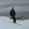
We’re not the only ones ski touring from Sunrise today.
 Viewed 1033 times")
Our first objective is the saddle west of Antler Peak, behind the upper left roof corner of the Sunrise day lodge here.
 Viewed 1033 times")
Patrick skinning up with a clear shot of Mt. Rainier behind him.
 Viewed 1033 times")
We reach the saddle at 6,750 feet about 35 minutes after leaving Sunrise parking at 10AM.
 Viewed 1033 times")
This is the northeast side of Mt. Rainier with its largest glacier Emmons.
From the saddle there’s a fairly mellow bowl at skier’s left, a slight steeper entry at center which I chose. But first Patrick climbed a bit farther right for this more aesthetic line:
 Viewed 1033 times")
 Viewed 1033 times")
 Viewed 1033 times")
 Viewed 1033 times")
 Viewed 1033 times")
 Viewed 1033 times")
 Viewed 1033 times")
 Viewed 1033 times")
Then I skied the center line.
 Viewed 1036 times")
 Viewed 1036 times")
 Viewed 1036 times")
 Viewed 1036 times")
From 500 feet below we looked up and saw another chute far looker’s right.
 Viewed 1033 times")
We considered booting up that but Patrick thought we might be tired after that and want to just ski back to the car. I reminded him that Chris had said the easiest exits were from Huckleberry Basin to the lowest and broadest saddle above the parking, so we traversed around the subpeak to our west. Once we got there we could always ski a north side run or two in Huckleberry Basin if we had the time and energy. First view into Huckleberry Basin from 6,190 feet:
 Viewed 1036 times")
Rather than doing one long traverse/skin across the basin we booted about 300 vertical up toward the base of the chute at left.
 Viewed 1036 times")
 Viewed 1036 times")
I’m at the top of our bootpack with Patrick a bit lower.
 Viewed 1033 times")
I’m skiing from there.
 Viewed 1037 times")
 Viewed 1037 times")
Followed by Patrick
 Viewed 1037 times")
 Viewed 1037 times")
Patrick spotted a skin track out of Huckleberry Basin so we followed that.
 Viewed 1037 times")
 Viewed 1037 times")
The fog came in on upper part of the skin track.
 Viewed 1033 times")
This was a relatively steep sidehill where I would have had trouble if a track weren’t set already. As it was I slipped twice. The second slip was about 50 feet from the top and the track was about to disappear so I took the skis off and booted the rest. Patrick has better skin technique learned from Lucky Luke at Shames so he was able to persist with the skins to the saddle at 6,650 feet.
 Viewed 1037 times")
Here I’m folding a skin.
 Viewed 1037 times")
Behind me is a broad east facing bowl that would be a mellow touring objective. Patrick and Morgane hiked along the top of that in 2006.
I’m pointing to our tracks in the far east side of Huckleberry Basin.
 Viewed 1037 times")
And here’s the very flat 200 vertical south facing and suncupped ski back to Sunrise parking. We got down about 2:30 after 4 hours and about 1,100 vertical of climbing and skiing.
 Viewed 1037 times")
Sunrise is a very accessible area when its road opens in June or July. There is a broad variety of quite easy to fairly steep ski terrain. Despite the spectacular views of Rainier this area is safely removed from glacier hazards. The highest peaks in this immediate area are no more than 7,200 feet, which means the snow melts out by August/September so the dedicated monthly ski streakers must go somewhere higher then.