Zion National Park: Narrows May 19, Echo Canyon May 23, 2012

Postby Tony Crocker » Wed Jun 13, 2012 6:11 pm

We planned to meet some of Liz' friends in Zion May 19. Unfortunately I got a flat tire in Las Vegas Friday evening, had to spend the night there and find a replacement Saturday morning. It was past 4PM when we got into Zion, so we took the shuttle to the end of the road and then the Riverside Walk and waded up the Virgin River Narrows. Virgin River at end of Riverside Walk.
IMGP1895.JPG

There is some current here; many people had walking sticks to assist balance. The flow has to be way down before people are allowed to wade upstream. Last year it did not open until after the July 4 holiday.

Some areas were wider, shallower with gravel
IMGP1900.JPG

The Narrows is a popular tourist spot but it was about 6:30PM and starting to thin out. It was useful to watch other people on the way out to tell where the shallow and deep spots were. We also took turns for group pictures.
IMGP1911.JPG


We turned around at this waterfall.
IMGP1919.JPG


And this viewpoint of it.
IMGP1921.JPG


We rarely had to wade much deeper than this.
IMGP1924.JPG


This was the first test for some water shoes I bought at Costco. They worked great in the Narrows, secure, strained the water with very little gravel getting caught. Unfortunately the mile returning on Riverside Walk to the bus stop started to blister both heels. I had to use moleskin and duct tape to protect them for the next 3 days of hiking. When we got back to Zion I bought neoprene water socks to use with the water shoes from now on.
http://bestsnow.net
Ski Records
Season length: 21 months, Nov. 29, 2010 - July 2, 2012
Days in one year: 80 from Nov. 29, 2010 - Nov. 17, 2011
Season vertical: 1,497K in 2016-17
Season powder: 291K in 2011-12
User avatar
Tony Crocker
 
Posts: 9405
Joined: Thu Sep 23, 2004 10:37 am
Location: Avatar: Charlotte Bay, Antarctica 2011
Location: Glendale, California
Top

Re: Zion National Park: Narrows May 19, Echo Canyon May 23,

Postby Tony Crocker » Wed Jun 13, 2012 7:12 pm

We had more time in Zion May 23. We did not get an early start as we had arrived late the night before driving from Lake Powell with dinner in Kanab. Via shuttle bus we started up the east Rim/Observation Point route at 11:30AM. We met lots of people on their way down. This trail is on the east side and shaded all morning. Fortunately it has somewhat of a north aspect and the Zion Canyon walls are so sheer that the 1,000 climb from the valley floor is still ~2/3 shaded midday. It was in full sun mid-afternoon on the way down but with some breeze and we didn't mind the warmth at that time. Panoramic view of the West Rim partway up.
IMG_0192.JPG


We also got a direct view into a tall but narrow gash in the rock north of Weeping Rock.
IMG_0198.JPG


After the steep part the trail is in Echo Canyon for a short time.
IMG_0220.JPG

The website guides instruct not to enter the slot here.

So we stayed on the trail another 1/4 mile or so.
IMG_0223.JPG

IMG_0226.JPG

We met two sets of hikers coming out of the slot. They liked it but warned that it was wet and cold. With the late start we got into the recommended entry about 1PM.
IMGP2410.JPG

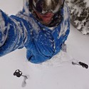
The water becomes neck deep just beyond me. It helped that the water was clear enough to see the bottom. Last year in Egypt 3 any water was opaque and muddy, though fortunately not too deep.

Just beyond that first pool. The exit was another one of those cases that was easiest by helping each other out.
IMGP2412.JPG


The slot rapidly becomes much taller, though at midday light is still reaching the bottom here.
IMGP2416.JPG


One more deep pool here.
IMGP2423.JPG

For a few feet it was safest to tread water and hold the pack above my head to keep it dry. Several items were in the red dry bag attached to my pack just in case. This pool was colder than the first one, so we were somewhat chilled afterwards.

Next was a shallow stepping stone pool followed by a 10 foot climb via some logs that had wedged into the slot many years ago.
IMGP2430.JPG

IMGP2431.JPG

Here at the top of the logs I stepped in some thin debris covering a hole which my whole leg went through, fortunately only sustaining a bruise and road rash.

That was the only real climb in this part of Echo Canyon. The walls towered above us but the bottom was mostly gravelly with just a few boulders.
IMGP2433.JPG

IMGP2450.JPG

IMGP2454.JPG

We took a lunch break in one of the few spots where sun reached the bottom to warm up. Farther up the canyon becomes narrower and darker.
IMGP2465.JPG

IMGP2467.JPG


Liz was still cold and wanted to turn back if we encountered more water. The first water was colder yet but less than knee deep so I went ahead to check it out.
IMGP2474.JPG

Just beyond me was more water that went waist deep and then around a blind corner so I knew we were done. Map shown below with the short section where we were in the Echo Canyon slot marked in black.
IMGP2366b.JPG

It may have been possible to get out the side canyon to the north to the East Rim Trail at the confluence not too far beyond us, but we were not sure of that.

So we retraced our route, down the logjam and back through the 2 deep pools. I'm moving a pack through the last pool here.
IMGP2479a.JPG

We were out of the slot at 3:30.

On the way down a view of the Organ and Virgin River Big Bend.
IMG_0233.JPG


Weeping Wall is now illuminated.
IMG_0236a.JPG


After bus shuttle, cleanup and change clothes we drove to Las Vegas for the evening.
http://bestsnow.net
Ski Records
Season length: 21 months, Nov. 29, 2010 - July 2, 2012
Days in one year: 80 from Nov. 29, 2010 - Nov. 17, 2011
Season vertical: 1,497K in 2016-17
Season powder: 291K in 2011-12
User avatar
Tony Crocker
 
Posts: 9405
Joined: Thu Sep 23, 2004 10:37 am
Location: Avatar: Charlotte Bay, Antarctica 2011
Location: Glendale, California
Top

Re: Zion National Park: Narrows May 19, Echo Canyon May 23,

Postby EMSC » Thu Jun 14, 2012 12:33 pm

Have to say Zion is a spectacular park.

Last time I was there (a decade ago already!) I did the Hidden Canyon trail right next to Echo. There's a nice bit of vertigo inducing trail with bolted chains and all to get you into Hidden Canyon.

I've always wanted to figure out a way to stage cars or etc... and do the full down-hike through the narrows from the rivers starting point up top. Apparently it's a long day in the water, but sounds like a fun challenge (just as long as no thunderstorms are forecast of course).
User avatar
EMSC
 
Posts: 1845
Joined: Wed Apr 11, 2007 6:54 pm
Location: Front Range of Colorado
Top

Re: Zion National Park: Narrows May 19, Echo Canyon May 23,

Postby Marc_C » Thu Jun 14, 2012 3:09 pm

EMSC wrote:I've always wanted to figure out a way to stage cars or etc... and do the full down-hike through the narrows from the rivers starting point up top. Apparently it's a long day in the water, but sounds like a fun challenge (just as long as no thunderstorms are forecast of course).

It's an extremely long day - most parties do it as an overnight trip. There are shuttles up to the Chamberlain Ranch starting point provided by the local outfitters. The road can be pretty rough and require high-clearance, depending on conditions that year. Permits (and the associated hassle of the lottery system) are required for overnight trips. There's a certain spot in the river where camping downstream from there is prohibited due to any potential campsites still subject to flash flooding. The Virgin River watershed is over 400 sq miles. You can drown in a flash flood from a T-storm 50 miles away that you can't even see or hear.

Because of all the rocks in the riverbed, travel times in the water are much longer than one would think from just looking at mileage. Also, a long walking stick (longer than any kind of adjustable trekking pole) is very helpful to maintain balance. Note that Tony actually did not make it to the true Zion Narrows - he stopped at the final rappel out of Mystery Canyon; that low angle waterfall, which is just barely into the first narrows section of Zion.
-marc
User avatar
Marc_C
 
Posts: 3079
Joined: Thu Mar 24, 2005 10:32 am
Location: A Sandy place south of a Great Lake
Top